


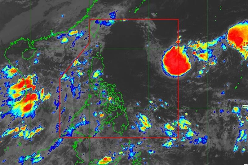
MANILA – The weather bureau announced that the tropical cyclone outside the Philippine Area of Responsibility (PAR) is anticipated to enter either by Wednesday night or Thursday.
The tropical depression, which was last observed 1,530 kilometers east of extreme northern Luzon, is expected to reach tropical storm category within 36 hours.
It will be given the local name, “Inday” once it enters PAR.
According to the Philippine Atmospheric, Geophysical and Astronomical Services Administration (PAGASA), a steady intensification is also possible as the tropical cyclone moves over the Philippine Sea.
PAGASA stated that the tropical cyclone is unlikely to bring heavy rainfall and severe winds.
It may cause moderate to rough seas, however, over the seaboards of extreme northern Luzon during the weekend.
Meanwhile, scattered rain showers and thunderstorms are forecast to prevail over Palawan, Western Visayas, Zamboanga Peninsula, Basilan, Sulu, and Tawi-Tawi on Wednesday due to the Intertropical Convergence Zone (ITCZ) affecting Palawan and Mindanao.
Due to moderate to occasionally heavy rainfall, flash floods or landslides are possible in these areas.
Localized thunderstorms will cause isolated rain showers across the rest of the country.
Over the entire archipelago, light to moderate winds and slight to moderate seas will prevail.

piano jazz music
Hello, the whole thing is going fine here and ofcourse
every one is sharing facts, that’s genuinely good, keep up writing.
For the reason that the admin of this site is working, no uncertainty very quickly it will be well-known,
due to its feature contents.
Hi i am kavin, its my first time to commenting anyplace, when i
read this piece of writing i thought i could also create comment due to this good piece of writing.
Why visitors still use to read news papers when in this technological globe all is existing on net?
Hello there, just became alert to your blog through
Google, and found that it’s truly informative. I am gonna watch out for brussels.
I will be grateful if you continue this in future. A lot of people will be benefited
from your writing. Cheers!
Very good post! We will be linking to this particularly great content on our website.
Keep up the great writing.
I think that is one of the such a lot important info for me.
And i’m happy studying your article. But want to statement on some normal issues, The website style is wonderful, the articles is truly excellent : D.
Good job, cheers
Normally I don’t learn post on blogs, but I wish to say
that this write-up very forced me to check out and do it!
Your writing style has been surprised me. Thanks, very
nice post.
Generally I don’t read post on blogs, however I would like to say that this
write-up very forced me to try and do it! Your writing style has been amazed me.
Thanks, very nice article.
I do not even know how I ended up here, but I thought this post was great.
I do not know who you are but definitely you’re going to a
famous blogger if you are not already 😉 Cheers!
I do consider all of the ideas you have offered in your post.
They are really convincing and will certainly work.
Still, the posts are too short for starters.
May you please prolong them a bit from subsequent
time? Thanks for the post.
Thanks a bunch for sharing this with all folks you actually
realize what you are talking about! Bookmarked. Kindly also
visit my website =). We can have a hyperlink exchange agreement between us
Hi! This is my 1st comment here so I just wanted to give a
quick shout out and tell you I genuinely enjoy reading through your posts.
Can you recommend any other blogs/websites/forums
that go over the same topics? Many thanks!
Wow, incredible blog format! How lengthy have you been blogging for?
you made blogging glance easy. The overall look of your web site is fantastic, let alone the content
material!