


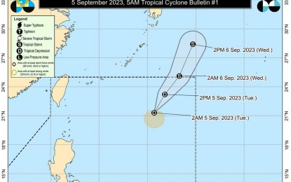
MANILA – The low pressure area (LPA) east of extreme Northern Luzon has developed into Tropical Depression (TD) Ineng at 2 a.m. Tuesday, the weather bureau said.
Ineng packs maximum sustained winds of 45 kilometers per hour (kph) near the center and gustiness of up to 55 kph. It was last tracked 925 km east of extreme Northern Luzon, the Philippine Atmospheric, Geophysical and Astronomical Services Administration said in its 5 a.m. bulletin.
Ineng is forecast to remain far from the landmass and could exit the Philippine Area of Responsibility on Tuesday night or Wednesday.
The TD’s trough will cause scattered rain showers and thunderstorms over Batanes, Cagayan and Isabela.
Moderate with at times heavy rains are likely, resulting in possible flooding and landslides.
Ineng is unlikely to directly affect the country.
However, it is slightly enhancing the southwest monsoon that may cause rains over the western portion of Luzon over the next three days.
On Tuesday, monsoon rains are forecast in Pangasinan, Zambales, and Bataan, while occasional rains will be experienced in Metro Manila, the rest of Ilocos Region, Abra, Benguet, Pampanga, Bulacan, Rizal, Cavite, Batangas, and Occidental Mindoro.
The southwest monsoon will also cause scattered rain showers and thunderstorms over the rest of Luzon.
The rest of the country will have isolated rain showers caused by the southwest monsoon and localized thunderstorms.
Meanwhile, no tropical cyclone wind signal is hoisted on any part of the country. The southwest monsoon will cause gusty conditions in Batanes, Ilocos provinces, the western portion of Pangasinan, Zambales, Bataan, Kalayaan Islands, Lubang Island and Romblon.
It will also cause rough sea conditions over the seaboards of Northern Luzon, the western seaboard of Central Luzon, the western and southern seaboards of Southern Luzon, and the western seaboard of the Visayas. (PNA)

Apreciate the recommendation. Will ttry it out.